
We left Strahan on the west coast of Tasmania to drive to Stanley on the far north-west coast. Stanley is about as far as you can get on the North West Coast before you hit open land. As always, we consulted Google Maps. It said Stanley was 253 kilometres and just over 3 hours away however, it suggested a long, dog leg, inland route on a main road. We wanted to take the scenic route through the Tarkine forest if possible and there was one obviously visible on the map, so I added a way point of a small town called Corinna on what looked like the more direct, more scenic route. Google Maps was having none of it and took us up the dog leg inland road, down a road to Corinna, back up the same road back onto the inland road then up to Stanley. It also added an hour onto the journey. We tried it again and added another way point at Arthur River, it did the same thing trying its damnedest to keep us on this inland main road as much as possible. Right! I added about 6 more way points along the road we wanted to take to see how long a drive it would be. Finally Google Maps relented and calculated the journey time along this road I’d really like to take. 5 1/2 hours for a journey of a similar length. I locked it in and as as we drove out of Strahan I wondered, “Was Google trying to tell me something?”
The Tarkine Drive
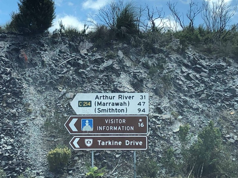
As we turned off the main road that Google loved to bits onto the road we wanted to take, there was a road sign. Just past the sign the tarmac road turned into a gravel road. I didn’t take a picture of the sign but it went something like..”You’re driving into the wilderness. The next petrol station is 175 kms away. All the roads are gravel roads. There is nothing or no one to help you between here and where you are wanting to get to. No phone, no internet, no Google Maps, fuck all. You’re on your own. If this worries you, you should turn back now and drive up the road Google told you to.”
The previous longest gravel road we drove was straight and flat and 27kms long in South Australia, this was going to be 150kms. We looked at the sign, looked at each other, nodded and drove into the wilderness. Carpe Diem. We had 250 kms of fuel left in the tank according to the fuel gauge. A 75 km buffer between us and the next fuel stop. This, however, was the last time I’d believe that bloody thing.

The Pieman and the Fatman
Along the gravel road we drove, mile after mile. Now, I know this is Australia and they’ve been using the metric system forever but it seemed we’d driven back in time. The road signs were in miles. We lost mobile signal almost as soon as we drove onto the gravel road and wouldn’t get it back again until we got to the other end. The Mazda 3 is a great car and travels well on tarmac roads but we were carrying a full load of gear and a packed roof box. The gravel road was good, but not flat. The suspension sits low when you pack family car full of gear and you feel every bump on the road. The sign said 80kph limit, we did 30kph. We drove around potholes, of which there were hundreds, and went at a crawl over the deep drainage ridges, of which there were dozens.

The Mazda never failed or faltered. The road was reasonably flat with no hills and our confidence in our decision to continue was growing. Eventually we saw the sign which said Corinna 2 miles. This was going to be a doddle we thought.

But, before we made it to Corinna we were confronted by the Pieman River. It was a mild surprise to find there was no bridge. The river is 130 metres wide and 20 metres deep and is crossed on a ferry called the Fatman Barge which you call by pressing a button on a post on the river bank.

We didn’t need to press the button as the captain or pilot or driver or whatever they are called, of the barge saw us.


The ferryman wouldn’t let me pay him. I guess he’d heard the song. You don’t know it? By Chris de Burgh? Look it up. He said we had to pay at the Hotel Reception in Corinna on the other side of the river.
Corinna
Corinna is located on the edge of the famous Tarkine Rainforest (the largest temperate rainforest in Australia) and is reputedly the northernmost point where the Huon pine grows. It is a remote historic mining town, now an eco-tourism stop off point. When I was looking at a Nature Photography holiday in Tassie once the most expensive, but most interesting, explored the Tarkine and was based here in the Eco Resort.

We paid for our trip across the river at the reception as instructed and the girl handed me a ticket. When I told her we had already crossed and were just calling into pay her she seemed shocked at our honesty. I was shocked at her being shocked. We ‘could’ have just driven past the hotel and on down the road, but who would do such a thing? The people here are trying to eke a living in a really remote, hard to get to but eye wateringly beautiful part of the world. They are doing the world a favour and need to keep every dollar they earn.
A short distance out of Corinna we came to a crossing. We could keep going and get petrol in 59 kms in Waratah or turn left and go through the forest. It was our last decision point.


I did the quick check and the Mazda AI computer said we had 170kms left in the tank. That was 25kms less of a buffer than when we started just a 50 kms ago, but still plenty. Marrawah petrol station here we come.

The drive out Corinna went up. And up. And up. The fuel gauge went down. And down. And down. The road followed the roller coaster contours of the land including the deep ravines complete with exciting drops and dramatic, wheel spinning climbs out.

The scenery was everything we had expected and more.

After a while the drops and climbs became normal and when you navigate 10 successfully you become confident you’ll make them all. This allowed us to look out an enjoy drive and the scenery more. Thankfully the most serious of climbs were tarmac otherwise we’d never have made it up them.

Eventually we made it to the top of the world.


I checked the fuel gauge again. We’d lost another 30kms of our buffer and were down to 20kms spare. If you run out of petrol here it could be a while before we were rescued. We’d passed the point of no return a long time back so we put the issue behind us, no point in sweating over something we could do nothing about, and drove on taking in this unique view.

For 2 more hours we drove through one of the most unspoilt parts of the world you’ll ever see. This is a forest full of ancient and rare endemic trees such as leatherwood, myrtle, laurel, celery top pine, sassafras, blackwood, eucalyptus and giant tree ferns. I could have stopped every 100 metres to take a picture. There were postcard perfect scenes everywhere you looked. Eventually we made it to the end of the gravel road and saw this sign. We’d made it through the Tarkine Way and what an experience it was. I know I say this a lot in this blog but if you ever get a chance, do this drive. Do it! You’ll not regret it. That is if you can persuade Google Maps to take you along it.
The Edge of the World
Marrawah, the nearest petrol station was 47 kms away, our gauges were telling us we had 57 kms of fuel left. We were going to make it. A thought made its way to the top of the brain which nagged at me saying, “Its Sunday, Marrawah is a tiny place. Bet it’s closed on Sunday. What are you going to do then?” Again, nothing I could do about it. I turned left to Arthur River and The Edge of the World.

In a previous blog, when we were in Sheffield I told you about about tourism pioneer Brian Inder who single handedly regenerated the town by having the walls covered by murals and by building a maze and the mini village of Crackpot. When researching him for this blog I discovered he also created The Edge of the World attraction.

Plaque at the Edge of the World
I cast my pebble onto the shore of Eternity.
To be washed by the Ocean of Time.
It has shape, form and substance,
It is me.
One day I will be no more.
But my pebble will remain here.
On the shore of Eternity.
Mute witness for the aeons.
That today I came and stood,
At the edge of the world.
Brian Inder

As soon as I read he’d created another attraction called The Edge of the World we had to go there. As it was “on the way” between Strahan and Stanley it was an obvious stop off point. We were not disappointed. There is not another place like this in the world, and here’s why.


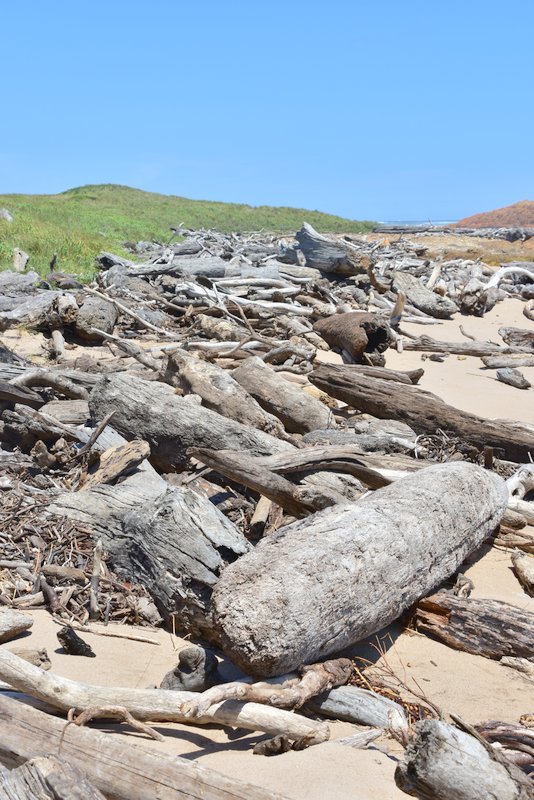
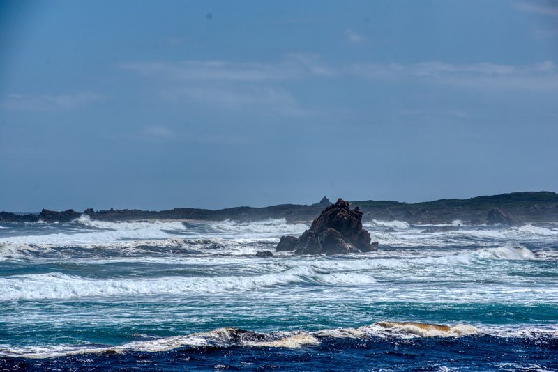
The Roaring Forties are strong west-to-east currents caused by the combination of air being displaced from the Equator towards the South Pole, the Earth’s rotation, and the scarcity of landmasses to serve as windbreaks. What that means is that the Trade Winds, as they were known, and the currents at 40 degrees south roar unhindered between Argentina under the Cape of Good Hope and the first land mass they hit is The Edge of the World in Tasmania which is between 40 and 42 degrees south. For thousands, millions of years, everything they pick up on their journey of 15,000 kms is dropped onto the coast at this point. The winds roar, the sea rages and the scenery is spectacular. This cannot be found anywhere else in the world. This is the end of the longest, uninterrupted expanse of ocean in the world.


The driftwood, which is everywhere, that looks like twigs in the pictures, are giant logs. The trunks of enormous trees that fell into the ocean somewhere, many thousands of kilometres away and many hundreds of years ago that have been blown onto the beach here at the Edge of the World.
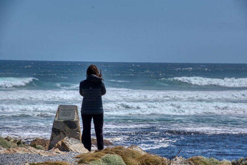
We spent a long time just ‘being’ in this place. It’s pretty special.

Leaving Arthur River we made it to Marrawah with 5 kms left in the tank, the garage was open and we filled up and drove to Stanley where we were to camp for the next week or so. There was a ‘little’ more drama to that last bit but I’ll gloss over it and move on.
Stanley

Stanley is the main fishing port on the north west coast of Tasmania. It was named after Lord Stanley, the British Secretary of State for the Colonies in the 1840s. We were here a couple of years ago and vowed to return and spend some time in this remote and rarely visited part of Tasmania. We knew two things about Stanley, one is the “Nut” or Munatrik as it was called by the indigenous peoples and the other is the Stanley Wind which is supposed to be relentless and a challenge for campers.
The beautiful Stanley camp site nestles under the Nut. They make a decent attempt at sheltering the camping sites from the incessant wind but it’s a bit like King Canute trying to hold back the tide. The wind finds you wherever you are. The facilities are top class though. We’ve rarely seen better in any camp site in Australia. While we were there a rare weather event was happening that caused torrential rainfall and gale force winds to roar through the camp site. Luckily our preparations and camp set up were based on our experiences previously and as a result we spent the time in Stanley in luxury, warmth and comfort.
We had several great meals in Stanley. One day we popped into the local bakery and ordered a Chicken Burger and a Crayfish Pie. I am not exaggerating when I say both of these dishes were spectacular and worthy of Masterchef. The pie filling was packed full of crayfish and sea food and the chicken burger was lightly coated in crisp buttermilk batter. Turns out the chef used to run a two hat restaurant. It showed. We went back again the next day it was so good.

Fiona, the friendly lady who owned the camp site, told us about this new restaurant that was opening while we were here. Tasmanian Food and Wine. We called in to check it out and, as happens with Jenni, struck up a great conversation with Michael who owns the place. He serves exclusively Tasmanian wine and food. The food is served on platters.

Michael and his partner bought this old house and refurbished it into this eclectic space. They have an eye for colour and beauty. It’s a work of art as well as an establishment.
They have created a unique and beautiful space. It’s well worth visiting. The platters are delicious.
The Nut
The Nut is a volcanic plug 143 metres high. Stanley town hugs the base of the Nut. It was originally named Circular Head by Matthew Flinders which is still the name of the region today. The Nut dominates the landscape. It almost impossible to take a landscape picture of worth in Stanley without the Nut in it somewhere.

The Nut is the stump of an old volcano. It’s the hard basalt core which is left after all the soft outer rocks have been eroded. The volcano was last active about 70 million years ago. If you made a volcano shape out of sand and filled it with molten iron. Then, when it cooled, you took a power hose and hosed away the outside it would look a bit like the Nut.
Erase the race and claim the place. The Van Diemen’s Land Company.
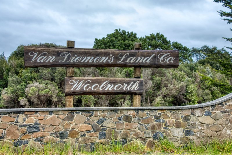
The history of Stanley is the history of the Van Diemen’s Land Company. We were oblivious of this until we went on a day trip to Woolnorth. We did not even know about the VDLC. As these things do while we are Vagabonding the trip to Woolnorth was a whim. I was scrolling around Google Maps and saw a large wind farm in Woolnorth, not far from Stanley. I love wind farms and wanted to get close to take some pictures. So one Saturday we went to visit.

As you can see from the picture the public is kept pretty far away from the turbines. I’m disappointed, but not surprised. I remember standing at The Edge of the World and being hammered by the Roaring Forties thinking, “This is a perfect pace to build a Wind Farm.” According to the Woolnorth Wind Farm web site they “take advantage of the world class resources that we are exposed to in Tasmania”
In other words it is windy as all hell, all the time, 24 hours a day, 365.2425 days a year, every year.** What better place to build a massive wind farm?

The Van Diemen’s Land Company was formed in 1825 in England. They were granted 250,000 acres in the newly discovered great southern land. There was a qualification however. The land was in the far North-West corner of Tasmania. Stud livestock, implements, craftsmen and indentured labourers from England along with convicts assigned locally landed in Stanley in October 1826 to create this new venture. I cannot gloss over this bit, they then went about clearing all the local indigenous peoples and decimating the landscape and local wildlife. They put a bounty on the Thyacine, the local Tasmanian Tiger, which resulted in it being hunted to extinction and killed all the Aborigines in the vicinity. Bunch of absolute fucking bastards.

The area back then was a dense forest. They cleared the land of trees and scrub and created farms for sheep and cattle. Stanley became the main township in the area. Their goal was to supply wool to the textile powerhouses in the north of England. The venture did not go well. By the 1880s the company was making more money from timber felling and timber exports than from farming. Today VDLC retains some of the original land grant and is widely believed to be the last Australian chartered company still operating.
Stanley Penguins
Stanley has a penguin colony that comes ashore every night. Probably because the VDLC didn’t see penguins as a threat to their profits. The local authorities have built a platform with red lights you can view the penguins from for free. We sooooo wanted to see penguins in the wild so of course we were there. Fiona told us the penguins come ashore at 9:40. She wasn’t wrong. However they took their time. Between 9:40 and 11:00 they silently scrambled ashore. The penguins in this part of the world are Fairy Penguins and they are tiny and grey. They are timid and won’t come ashore if they sense danger. Bright light scares them so all the lights are red. It makes for a challenging photo shoot.

OK, I am a little embarrassed about these pictures of penguins in the wild. The same day I took these a friend of mine based in the Falkland Islands posted the most amazing scenes of thousands of penguins up close and personal. The only reason I am including them is for the memory.

We were having such a good time in Stanley it seemed too soon it was time to leave. We were on our way to Hobart for a quick stop before our Christmas holiday break on Bruny Island. All of that is in the next blog. Here’s a sneak preview.

**As there are 366 days in the year every four years if you observe the Gregorian calendar it averages out to 365.2425 every year.

Great tale. The remoteness and wildness of it reminds of that other end of the world, at the southern tip of the South American continent. Assuming a lot of that driftwood originated there.
LikeLike
Hi Jim,
I’m down in Hobart for a while. If you want to catch up give me a call.
Jim Ramsay
LikeLike